Resource Library
Funding Opportunities
The "Funding Opportunities for Farmers" database collects information on grants and other programs that provide funding directly to farmers and ranchers. All of the opportunities listed are available on the Central Coast. This database will be updated regularly with new opportunities and current application deadlines.
View the Funding Opportunities Database Here
Local Groups and Committees
San Luis Obispo County Weed Management Area
Water Resources Advisory Committee (WRAC)
Agricultural Liaison Advisory Board (ALAB)
Local Watershed Information
SLO Watershed Project - Watershed maps and data for San Luis Obispo County.
Upper Salinas River Watershed Action Plan (WAP) – A comprehensive planning document, a management plan, for the use by landowners, agencies and groups in their individual and collective efforts to improve and restore natural resources within the 2,000 square mile area of the Upper Salinas River Watershed. The planning area comprises approximately one-quarter of the watersheds that affect the Monterey Bay National Marine Sanctuary (MBNMS). This document includes the input from hundreds of persons, agencies and organizations.
Santa Rosa Creek Watershed Management PlanSanta Rosa Creek Watershed Conservation PlanSLO County Percolation Zone Study
Soil Health
CDFA Healthy Soils Program - The Healthy Soils Program stems from the California Healthy Soils Initiative, a collaboration of state agencies and departments to promote the development of healthy soils on California's farmlands and ranchlands. The HSP has two components: the HSP Incentives Program and the HSP Demonstration Projects. The HSP Incentives Program provides financial assistance for implementation of conservation management that improve soil health, sequester carbon and reduce greenhouse gas (GHG) emissions. The HSP Demonstration Projects showcase California farmers and rancher's implementation of HSP practices.
Erosion Control Handbook – designed to provide information to planners, developers, engineers and contractors on the proper selection, installation and maintenance of BMPs. The handbook is intended for use during the design and construction of projects that require erosion and sediment controls to protect waters of the state. It also explains meeting various regulatory agencies permit requirements.
Erosion Control Handbook – designed to provide information to planners, developers, engineers and contractors on the proper selection, installation and maintenance of BMPs. The handbook is intended for use during the design and construction of projects that require erosion and sediment controls to protect waters of the state. It also explains meeting various regulatory agencies permit requirements.
Water Resources
Creek Stewardship Guide for San Luis Obispo County – A useful guide to give rural and urban landowners a sense of their place in the many watersheds found in SLO County. The Creek Stewardship Guide promotes practical creek care information and offers a host of resources to help with the maintenance and preservation of creek-side property.
Sustainable Groundwater Management Act Portal - The Sustainable Groundwater Management Act (SGMA) Portal is a tool accessible to both agencies and the public. With no account login required, the public has the ability to view and download information related to groundwater sustainability agencies (GSAs), groundwater sustainability plans (GSPs), alternatives to GSPs, adjudicated areas, and basin boundary modifications. Public comments can also be submitted to the Department without a login. Local agencies, GSAs, and watermasters are required to use the SGMA Portal to submit, modify, and view the information required by the ), such as GSPs.
Quality Assurance Project Plan (QAPP) – developed from the Watershed Action Plan to provide detailed protocols for stream water quality, channel morphological characteristics, vegetative cover and condition and stream flow. The QAPP provides measures that will insure that each monitoring activity is consistent and accurate.
Upper Salinas River and Tributaries Watershed Fisheries Report and Early Actions report – examines the current conditions of Southern steelhead in the Salinas River. The Salinas has been listed as a “Category 1, Impaired Watershed” and is one of the most critical rivers in California by the State Water Resources Control Board due to its degrading condition and the impacts of nonpoint pollution on water quality. During the 1900’s the Salinas River supported large numbers of steelhead. Today steelhead populations have reduced considerably as a result of damming of the river, urbanization and agriculture.
Agricultural Resources
Agricultural Management Handbook – intended for use by all agricultural practitioners including landowners, land managers, governmental agencies and local organizations involved in agriculture. The handbook details how Best Management Practices (BMP’s). and properly managed agriculture can provide food, employment, economic vitality, beautiful scenery and sustain our natural resources. One of the strengths of the U.S. Agriculture is the, “willingness of farmers to adopt proven alternatives”, practices that enhance production, improve economic returns and conserve soil, water, energy and biological resources.
Grazing Lands Management – Nacitone – for the Monterey County Water Resources Agency (MCWRA) land within the Nacimiento and San Antonio River Watersheds (Nacitone). The MCWRA operates the Nacimiento and San Antonio Reservoirs for flood control, ground water recharge and to control saltwater intrusion near Monterey Bay. The plan is a part of a comprehensive Integrated Watershed Management Plan (IWMP) being drafted for the Nacimiento River Watershed and the San Antonio River Watershed. The IWMP is a community wide planning effort, funded by the State Water Resources Control Board (SWRCB) and managed by MCWRA. The plan provides guidance for the MCWRA to incorporate Best Management Practices (BMP’s) in order to comply with the goals of the Clean Water Act (1972) by reducing nonpoint pollution entering the water bodies within the Nacimiento and San Antonio watersheds.
Grazing Lands Management – Nacitone – for the Monterey County Water Resources Agency (MCWRA) land within the Nacimiento and San Antonio River Watersheds (Nacitone). The MCWRA operates the Nacimiento and San Antonio Reservoirs for flood control, ground water recharge and to control saltwater intrusion near Monterey Bay. The plan is a part of a comprehensive Integrated Watershed Management Plan (IWMP) being drafted for the Nacimiento River Watershed and the San Antonio River Watershed. The IWMP is a community wide planning effort, funded by the State Water Resources Control Board (SWRCB) and managed by MCWRA. The plan provides guidance for the MCWRA to incorporate Best Management Practices (BMP’s) in order to comply with the goals of the Clean Water Act (1972) by reducing nonpoint pollution entering the water bodies within the Nacimiento and San Antonio watersheds.
Cal Poly Irrigation Training & Research Center - Our Mobile Irrigation Lab (MIL) Program conducts irrigation system evaluations utilizing methodology developed by Cal Poly’s Irrigation Training and Research Center. The Irrigation Training & Research Center was established in 1989 at California Polytechnic State University, San Luis Obispo, as a center of excellence, building on a history of contributions to the irrigation industry.
Seeding Information- Rangeland and Pasture ManagementForage Production Central Coast 2001-2019.pdfRecharge Basins– Groundwater Banking On Agricultural Lands
Biological Information
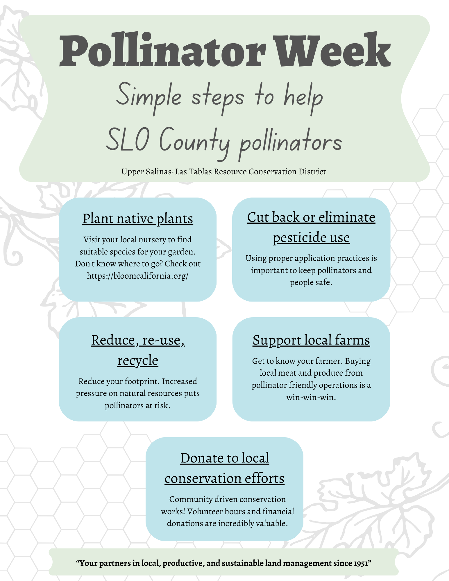
Simple Steps to help pollinators.pngPollinator Conservation Resources: California - Xerces Society
Monarch Conservation Plan - Western Association of Fish and Wildlife Agencies
S-CCC Steelhead Recovery PlanCalifornia Red-Legged Frog Recovery PlanFranklin 1999 Steelhead Observation
Erosion Control Short Course – April 23, 2012
Grading Ordinance Update – Murry Wilson & Michael CongerErosion Control Basics – Ron HarbenPermits – David AtheyConsequences – Daniel Mountyjoy (was not presented at workshop)Erosion Control on Construction Sites – David AtheyCaltrans Erosion Control – Scott Dowlan
